Mad River Riders Ride Guide
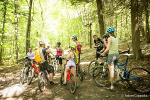
Ride, ski, run and walk in control. Bikers and skiers always yield to walkers, runners and snowshoers. Climbing traffic has the right of way. Please stop in a safe visible spot off the trail. Stay off trails when conditions are very wet or the ground is soft. Build and maintain with only with permission. Avoid skidding, leaving deep footprints or tire tracks. Please park legally and respectly. Keep pets under control. Leave no trace. Respect the neighbors and other visitors. Smile.
Mad River Riders Easy Loop
Trailhead – Park off Plunkton Rd. near the dam or by the waterfront access. Trailhead and sign are on the west side of Plunkton Rd., opposite the lake.
Stats – Beginner/ Intermediate – ~6 miles – 550 vert ft
Route – Tootsie Roll to Lenord’s Loop to Flying Squirrel to Lenord’s Loop
The Blueberry Lake trails feature gentle grades, sweeping turns and flowy lines. Start slowly and learn the lines, before increasing speed. Be aware of guide stones near the edges of the trail. These help “guide” users to stay on the trail, which reduces impacts and maintenance.
Tootsie Roll
Expect some of the sweetest trail views in the Mad River Valley on Tootsie Roll, the easiest option at Blueberry Lake. Start at the main trailhead on Plunkton Rd, go past the entrance to Lenord’s Loop, then right at the next intersection onto Tootsie Roll. Climb through the field, be sure to pick your head up for the vistas. After the field, the trail gets more rolly, with a few easy technical features, before reconnecting with itself near the Lenord’s Loop intersection.
Lenord’s Loop
Turn on to Lenord’s Loop at the trailhead sign and descend a rocky section to a bridge over a stream. After crossing, climb briefly until reaching an intersection. Go right for an easier climb, left for a moderately tougher ascent. These routes reconnect at a main intersection with the upper loop, Flying Squirrel.
Lenord’s Loop is named for Lenord Robinson, the original designer of Blueberry Lake and the owner of Blueberry Lake Touring Center.
Flying Squirrel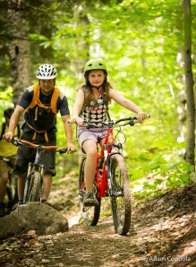
At the Lenord’s Loop/ Flying Squirrel intersection, choose the upper option for the best downhill. Flying Squirrel loops back to the intersection, regardless of which direction you choose. For a quick steep exit, you can drop down the Quarry trail, about .25 mile from the main intersection. We recommend finishing on Lenord’s Loop, though.
________________________________________
Mad River Riders Intermediate Loop

Enchanted Forest
Trailhead – Camel’s Hump State Forest parking area, near top of Tucker Hill Rd., off RT 17
Stats – Intermediate – 3.4 miles – 400ft
Route – Enchanted Forest – Dana Hill Rd – Cyclone Connector – Enchanted Forest
This fun lollipop loop for aspiring riders is a mix of Class IV road and wider trails, with easier stretches, moderately technical rock features and a few stream crossings in fun rolling terrain.
Enter Enchanted Forest trail from parking area, cross stream on narrow bridge, then climb under a powerline and maple sap lines to a rocky high point. Descend through open mixed hardwoods leading into a stand of pines. Stay straight at Cyclone Connector, continue downhill through pines to Dana Hill Rd.
Go left on Dana Hill Rd, descend briefly and then climb to Cyclone Connector intersection, on left side of the road. Take left turn off Dana Hill Rd, climb past Cyclone entrance, continue up, then traverse to Enchanted Forest intersection. Go right on Enchanted Forest, climb to the rocky high point and descend back to parking area. Check out the stone structures on Enchanted Forest, built by Sustainable Trailworks. What was mud is now a work of art.
____________________________________________
Mad River Riders Expert Loop 
Trailhead – American Flatbread parking lot – please respect open container laws at all times here and park elsewhere on Fridays and Saturdays after 4PM. Also Lareau Swim Access, RT 100
Stats – Expert – 8.25 miles – 2090 ft
Route – Revolution – Dana Hill Rd – Clinic – Busternut – Dana Hill Rd – Enchanted Forest – Cyclone Connector – Cyclone – Revolution
This classic route serves up a heaping plate of the Mad River Valley’s toughest technical riding and tastiest flowy terrain. On Clinic, Busternut and Cyclone, expect tight old school features with moderate exposure. Learning the lines helps the flow, but the terrain is often unrelentingly challenging. Be prepared.
Revolution links the Camel’s Hump State Forest network to American Flatbread/ Lareau Swimhole and to Waitsfield Village via the Mad River Path. Revolution is an intermediate trail with mainly moderate pitches and a wider smoother tread.
Many thanks to the landowners; the Laskovskis, the Featherbed Inn and American Flatbread/ Lareau Farm Inn, and all of our volunteers and donors, especially Walt Silbernagel, John Cole, Sean Flynn, Green Mountain Valley School and Woods-CRW.
The Revolution trailhead is just past the far corner of the parking lot, at the edge of the big play field and marked by a forked tree with a bike wheel in it. Climb steadily on a wide trail, cross several streams, roll up a series of bermed switchbacks, before a final traverse and short downhill to the Dana Hill Rd intersection. On the opposite side of the road is the bottom of the Cyclone trail, which is generally ridden as a downhill.

GMVS rocks the Revolution!
Turn left and climb steeply on Dana Hill Rd. Please be quiet in this area to respect the landowners. Dana Hill Rd is one of the most difficult “roads” in the region. Not recommended for driving, it is a steep Class IV deadend single wide route, with lots of muffler-eating waterbars (jumps). Traffic is light (almost non-existent) and generally slow, but be mindful of approaching vehicles and horses.

Revolution boardwalk.
Climb 3/4 of a mile, when the pitch mellows, look for a left onto Clinic, marked with a small white blaze. Generally descend through a series of rock, root and dirt challenges, until a double stream crossing and the beginning of the climb to Busternut. Traverse and generally climb to the GS intersection.
At the Clinic/GS/Busternut intersection, go left on Busternut and climb, sometimes steeply, winding through a series of old stone walls, until topping out on Dana Hill Rd. Turn right and generally descend Dana Hill Rd for 1/4 mile.
Enchanted Forest and Cyclone Connector are a nice intermediate palate-cleanser, with a few stream crossings and enough tech to keep everyone happy. Although it is a fun loop, if you are feeling tired or pressed for time, you can skip this section by staying on Dana Hill Rd.

Cyclone flow.
Turn left onto Enchanted Forest and begin climbing a wide rolling trail through tall pines. After a challenging stream crossing, turn right onto Cyclone Connector at a large intersection. Descend on a flowy trail. After a wide stream crossing, the trail will start to gently climb. Look for the left to Cyclone, a narrower singletrack, at the top of a little rise, a few feet above the Dana Hill Rd intersection.

Cyclone slab.
The top of Cyclone is equal parts climb and descend, with lots of technical rock to chew. The middle and bottom become more gravity-fed, but there are little ups all the way down. After a long bridge, and a few more turns, cross Dana Hill Rd and directly enter Revolution on the other side of the road.
Climb for a short bit and then it is a long fun flow to the finish at Flatbread. How about a Lawson’s to quench your thirst? Did you put your name on the wait list before your ride? Good plan.
